 Floating Texas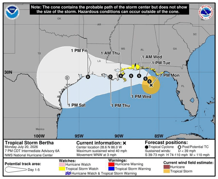
First the Floods. Now Big Bertha.
The upper Guadalupe jumped more than 30 feet in hours, the Frio hit major flood stage near Uvalde, and Tropical Storm Bertha is crawling across the Gulf toward Texas.
Filed Tuesday, July 21. Conditions and the Bertha forecast will change. Check the linked gauges and the National Hurricane Center for the latest.
When we last wrote about this storm system, the Frio at Concan had jumped to 4,240 cfs and the rain was still falling. It kept falling. By Thursday morning the Hill Country was in a full flood emergency, and now, before the rivers have even settled, there is a named storm in the Gulf.
What the upper Guadalupe did
Thursday morning was the worst of it. The Guadalupe at Hunt rose from 9 feet to 19 feet in a single hour before dawn, and the gauge read 37 feet just before 6 a.m., according to NBC News. Near Comfort, USGS data showed the river climbing from 5.46 feet at 5 a.m. to just over 37 feet by 8:05 a.m. Flood sirens sounded along the river, NPR reported, and Kerrville residents were ordered to shelter in place as rescues ran from Hunt through Ingram, Kerrville, and Center Point. At least two people died, and Texas Game Wardens reported more than 40 rescues, per CBS News, which also reported a disaster declaration covering 28 counties.
The Frio and the country around it
The Frio went into major flood below Dry Frio near Uvalde on Thursday night, with a flash flood warning covering the river near Concan, according to the Texas Tribune. Parts of Uvalde County took as much as 20 inches of rain. On Friday morning, floodwater on the Nueces took out a section of the FM 481 bridge south of Uvalde, Fox Weather reported. Downstream stretches were still rising into the weekend even as the headwaters receded.
Nobody should be floating the Frio or the upper Guadalupe right now. Check the live Frio and Guadalupe pages before you make any plans, and treat every low water crossing as suspect.
Here comes Big Bertha
Tropical Storm Bertha formed Monday evening in the northeastern Gulf, the second named storm of the season, per KXAN. As of the National Hurricane Center's 7 p.m. Monday advisory, the one shown in the cone graphic above, Bertha had 40 mph winds and was crawling west-northwest at 3 mph. The forecast track hugs the Gulf Coast all week and brings the center toward Texas late Thursday into Friday.
The good news, for now, is that forecasters expect limited impacts on the Texas coast, with 2 to 4 inches of rain along the Gulf Coast and isolated totals near 8 inches. The bad news is where that rain would land. The ground across the Hill Country is saturated, the rivers are running high, and last week proved how fast runoff moves when the soil cannot take another drop.
A weak storm over dry ground is a nuisance. A weak storm over this ground is worth watching closely. Keep an eye on the National Hurricane Center through the week, keep emergency alerts on, and give the rivers time to come back down before you do.